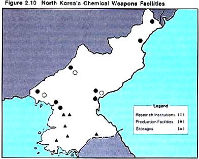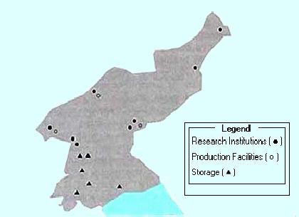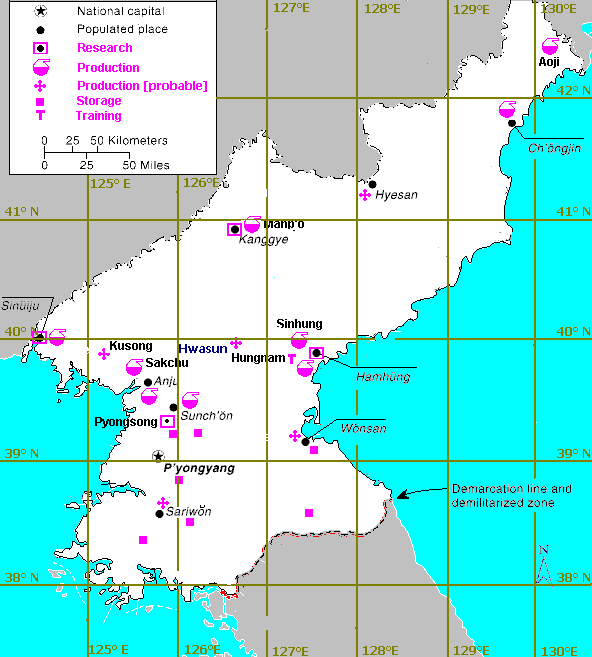


The 1999 South Korean White Paper states that "At present, North Korea maintains eight chemical factories, four research facilities, and six storage facilities for mass producing chemical agents" without providing further detail or a map of locations. The South Korean White Paper sources provide maps without placenames, and are the only source to indicate the location of chemical weapons storage facilities [the 1997 version of the map clearly transposes the labels for the production and research facilities]. There is generally fairly good agreement between the two version of this map, with the annoying exception of the second production facility in the vicinity of Hamhung [tentatively identified as Sinhung], and the displacement of the coastal facility that is apparently Ch'ongjin. It is not immediately possible to associate specific major North Korean military facilities with the indicated chemical weapons storage site locations on these maps. The locations generally seem to lie in fair proximity to airfields, though this may be entirely coincidental, as both airfields and military facilities generally are profoundly abundant in such close proximity to the Demilitarized Zone, the immediate precincts of which are highly militarized.
There is general agreement among these various sources that the North Korean chemical weapons program is centered in three or four research facilities, along with at least seven or eight production facilities, for a total of between ten and twelve locations. The four probable research facilities may be fairly readily identified as being located at Hamhung, Kanggye, Pyongsong, and Sinuiju, in addition to the probable training facility at Hungnam. However, there are as many as fifteen suggested locations for the production facilities.The number of possible production locations may be reduced to a dozen by the expedient of assuming that different sources use different placenames to refer to a single facility located between the named population centers. Anju [N39�37' E125�39'] mentioned only in LOC and Pyongwon [probably N39�18' E125�35'] mentioned only by CJH are probably the same facility at a location intermediate between these two population centers]. This facility may also account for the "Pyongyang" facility mentioned only in JPRS-UMA. Similarly, the Nampo [N38�43' E125�24'] facility mentioned by JPRS-UMA may be the same one referred to as Sariwon [N38�30' E125�46'] by JPRS-TMD.
The Library of Congress source uses more than a few non-standard placename transliterations. Seven of the nine facilities mentioned in the Library of Congress source can be readily associated with locations on the map from the ROK source. The Sinhung association is ambiguous, since there are several populated places with this placename, the location of one of which is not obviously inconsistent with one of the locations on the ROK maps, the identity of which is otherwise obscure [and the location of which is somewhat uncertain, since the position of this facility differs noticeably between the two editions of the map]. Within the limits of the cartographic license normally associated with such a small map, there appears to be generally good agreement between the LOC and ROK sources. The JPRS-TND source attributes chemical facility locations tot the 1991 DIA publication "North Korea: The Foundations for Military Strength," but the publication itself does not appear to include this information. Furthermore, the JPRS-TND source mentions only three locations attested to by the other sources, and includes some facilities with unidentified locations.It is possible to exclude Kusong, Wonsan and Yonan, which are attested by only single secondary derivative sources of uncertain reliability.
14	   Site             Lat      Lon                SOURCES
	                                         LOC  ROK  CJH  TND  UMA

 1 	 P Aoji             N42�31'  E130�23'     +     +
 2	 P Ch'ongjin        N41�47'  E129�46'     +     +              +
 3	RP Hamhung Hamhng   N39�54'  E127�32'     +     +    +    +    +
 4	TP Hungnam          N39�49   E127�37'                     +    +
 5	 P Hwasun           N39�52'  E126�32'           ??
 6	 P Hyesan           N41�24'  E128�10'                +    +
 7	R  Kanggye          N40�58'  E126�35'     +     +    +    +
 8	 P Manp'o           N41�08'  E126�21'     +     +
 9	R  Pyongsong        N39�15'  E125�51'                     +
10	 P Sakchu  Sakju    N40�23'  E125�02'                +    +
11	 P Sinhung         ?N40�11' ?E127�33'     +     ??
12	RP Sinuiju          N40�06'  E124�23'     +     +
13	 P Sunchon Sunch'n  N39�25'  E125�50'     +     +    +    +    +

14	 P Anju             N39�37'  E125�39'     +
	 P Pyongwon         N39�18'  E125�35'                +
	 P Pyongyang        N39�     E125�40'                          +

15	 P Sariwon          N38�30'  E125�46'                     +
	 P Nampo            N38�43'  E125�24'                          +


16	 P Kusong           N39�58'  E125�15'                          +
17	 P Wonsan           N39�09'  E127�26'                     +
18	 P Yonan            N37�54'  E126�09'                          +

POSSIBLE CW STORAGE SITES

 	 S Anbyon           N39�05'  E127�29'                     ??
 	 S Ch'obong-ni [?]  N38�45'  E126�05'          +
	 S Onjong-ni        N39�18'  E126�04'          +
  	 S Masang-dong      N39�10   E125�49'          +
 	 S Nuchonri         N38�15'  E126�10'          +
 	 S Pyonggang        N38�30'  E127�30'          +
 	 S Sinchon          N38�20'  E125�30'          +

